Garmin U.S.A. app review: advanced road trip navigator with photo-realistic view
Introduction
Garmin U.S.A, also known as StreetPilot, is an advanced road navigation system packed with useful features. It offers a fully customizable route creator, trip computer, real time road navigation with voice support, offline maps, and photo-real view of road junctions and intersections. This app is perfect for your iPhone and iPad.
The best mileage tracking apps for iPhone and iPad 2021
Garmin U.S.A.
A User-friendly GPS Road Navigation System
Garmin is one of the biggest producers of advanced navigation equipment. It is known for its state-of-the-art professional-grade GPS systems and hardware. With the Garmin U.S.A StreetPilot, you can now have a mobile road navigator for your iOS device.
The best iPad apps for finding gasGarmin U.S.A StreetPilot is a premium app that offers complete access to a range of advanced navigation technologies. The app offers sophisticated features that can make your road trips more convenient and safer.
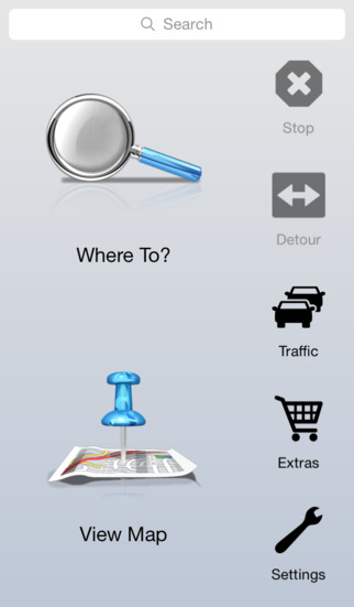
When you load this app, you will be welcomed by the familiar user interface of Garmin’s standalone road navigation device. There are two large animated icons at the home screen: the “Where To” and “View Map” menus. Additional menus such as extras, traffic, and settings are located at the bottom of the screen.
Tapping the “Where To” button opens at least a dozen options including destination input, points of interest, recent trips, favorite places, cities, road intersections, and more. You can type the destination address to start creating a trip route. You may also create a pre-set route based on the point of interest you want to visit.
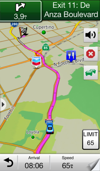
When you hit the road, just tap the “View Map” icon and select a route you created. You will then see a detailed map with road directions, street names, speed limit indicators, points of interest, and other key data. The app can give you turn-by-turn directions and will display a photo-view of important junctions in 3D.
Best Features of Garmin U.S.A.
Garmin U.S.A. offers a sophisticated voice-prompted driving assistant. It can provide detailed driving directions in a clear voice including street names, next exits, and major road landmarks.
Best iphone and ipad appsThe app offers hundreds of points of interest organized in intuitive categories and sub-categories. It will show key POIs along your route and freeway exit points. The app uses universally accepted road symbols to mark different POIs on the map.
One of the best features of Garmin U.S.A. is the offline map. The app downloads complete map data to your device so you can access them even if you have no Internet connection.
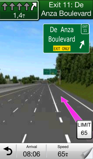
Another great feature of the app is the virtual lane assistant. This tool offers a photo-realistic view of the road and crucial junctions. The app will show you the correct lane to take using arrow indicators and distance data.
Other powerful features of Garmin StreetPilot include real-time traffic info, emergency locator, trip computer, trip log, weather reports, speed trap camera database, and location sharing via Facebook.
Garmin U.S.A.
Pros and Cons
Pros
- Easy to use with visual interface
- Impressive road animation, 3D junction view, and street view
- Offers accurate US road maps
- Works offline
- Virtual lane assistant
- Offers easy-to-use trip and route planner
Cons
- Use of GPS quickly drains your device battery
Final Words
Garmin U.S.A. is a full-featured road navigator with offline maps and impressive visual interface. It is a useful tool for those who are taking a road trip across the United States.
Garmin U.S.A.